USDA unveils updated Plant Hardiness Zone Map
The U.S. Department of Agriculture (USDA) released a new version of its Plant Hardiness Zone Map (PHZM), updating this valuable tool for gardeners and researchers for the first time since 2012. USDA’s Plant Hardiness Zone Map is the standard by which gardeners and growers can determine which plants are most likely to thrive at a location. The new map—jointly developed by USDA’s Agricultural Research Service (ARS) and Oregon State University’s (OSU) PRISM Climate Group—is more accurate and contains greater detail than prior versions.
It is available online at https://planthardiness.ars.usda.gov/. In addition to the map updates, the Plant Hardiness Zone Map website was expanded in 2023 to include a “Tips for Growers” section, which provides information about USDA ARS research programs of interest to gardeners and others who grow and breed plants.
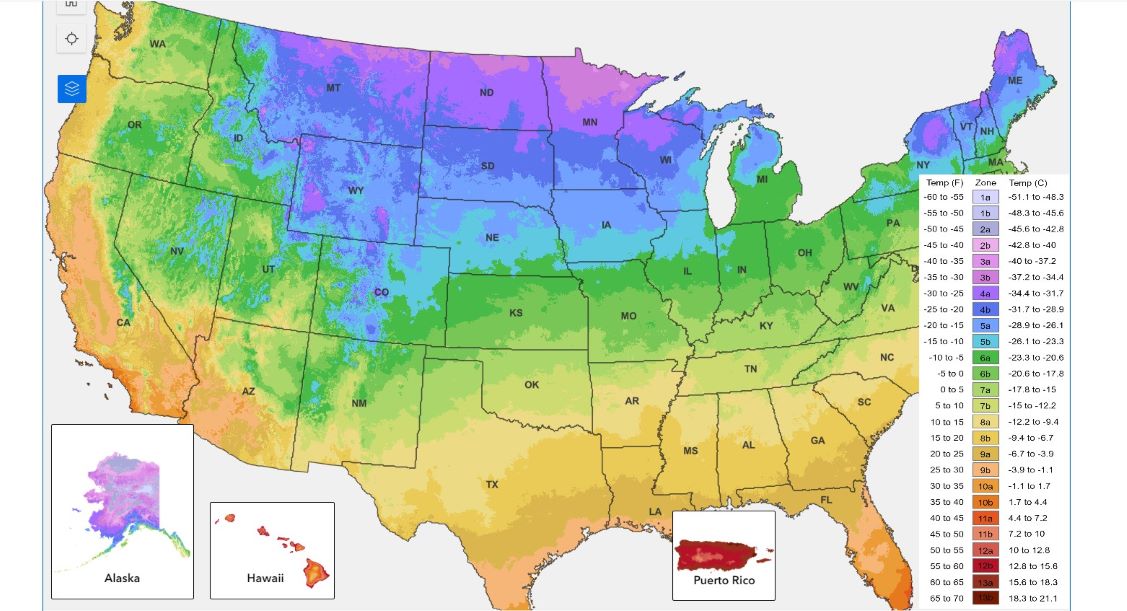
The 2023 map is based on 30-year averages of the lowest annual winter temperatures at specific locations, is divided into 10-degree Fahrenheit zones and further divided into 5-degree Fahrenheit half-zones. Like the 2012 map, the 2023 web version offers a Geographic Information System (GIS)-based interactive format and is specifically designed to be user-friendly. Notably, the 2023 map delivers to users several new, significant features and advances. The 2023 map incorporates data from 13,412 weather stations compared to the 7,983 that were used for the 2012 map.
Furthermore, the new map’s rendering for Alaska is now at a much more detailed resolution (down from a 6 ¼ -square-mile area of detail to a ¼ square mile). “These updates reflect our ongoing commitment to ensuring the Plant Hardiness Zone Map remains a premier source of information that gardeners, growers and researchers alike can use, whether they’re located in the continental United States, Alaska, Hawaii or Puerto Rico,” said ARS Administrator Dr. Simon Liu.
Approximately 80 million American gardeners and growers represent the most frequent users of the USDA Plant Hardiness Zone Map. However, they’re not the only ones with a need for this hardiness information. For example, the USDA Risk Management Agency refers to the map’s plant hardiness zone designations to set certain crop insurance standards. Additionally, scientists incorporate the plant hardiness zones as a data layer in many research models, such as those modeling the spread of exotic weeds and insects.
Plant hardiness zone designations represent what’s known as the “average annual extreme minimum temperature” at a given location during a particular time period (30 years, in this instance). Put another way, the designations do not reflect the coldest it has ever been or ever will be at a specific location, but simply the average lowest winter temperature for the location over a specified time. Low temperature during the winter is a crucial factor in the survival of plants at specific locations.
As with the 2012 map, the new version has 13 zones across the United States and its territories. Each zone is broken into half zones, designated as “A” and “B.” For example, zone 7 is divided into 7a and 7b half zones. When compared to the 2012 map, the 2023 version reveals that about half of the country shifted to the next warmer half zone, and the other half of the country remained in the same half zone. That shift to the next warmer half zone means those areas warmed somewhere in the range of 0-5 degrees Fahrenheit; however, some locations experienced warming in the range of 0-5 degrees Fahrenheit without moving to another half zone.
These national differences in zonal boundaries are mostly a result of incorporating temperature data from a more recent period. The 2023 map includes data measured at weather stations from 1991 to 2020. Notably, the 2023 map for Alaska is “warmer” than the 2012 version. That’s mainly because the new map uses more data representing the state’s mountain regions where, during winter, warm air overlies cold air that settles into low-elevation valleys, creating warmer temperatures.
The annual extreme minimum temperature represents the coldest night of the year, which can be highly variable from year to year, depending on local weather patterns. Some changes in zonal boundaries are also the result of using increasingly sophisticated mapping methods and the inclusion of data from more weather stations.
Temperature updates to plant hardiness zones are not necessarily reflective of global climate change because of the highly variable nature of the extreme minimum temperature of the year, as well as the use of increasingly sophisticated mapping methods and the inclusion of data from more weather stations. Consequently, map developers involved in the project cautioned against attributing temperature updates made to some zones as reliable and accurate indicators of global climate change (which is usually based on trends in overall average temperatures recorded over long time periods).
Although a paper version of the 2023 map will not be available for purchase from the government, anyone may download the new map free of charge and print copies as needed.